Update 1900: 27,930 acres 5% This afternoon fire behavior became extreme with plume domination, crown runs and long range spotting.
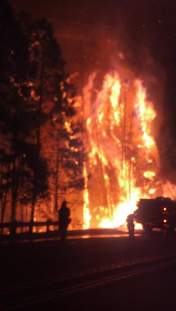 |
| On scene #KingFire photos from CHP Officer Mike Powers |


 |
| King Fire Hotspot map |
The King Fire is currently located in the canyon of the South Fork of the American River north of the community of Pollock Pines.
Special Announcements: Public Meeting - Wednesday at 6:30 PM. Georgetown Elementary School at 6530 Wentworth Springs Road, Georgetown, CA 95634.
Evacuations: Evacuations: 2,155 people
For a full list of the individual roads go to the Sheriff's blog at http://http://pio.edso.org/.[NEW] Shelter Location: Moved to the Camino Seventh-day Adventist Church at 3520 Carson Road, Camino, CA 95709.
Note- The mandatory closure to all residences south of Highway 50 between Fresh Pond and Riverton has been changed to a voluntary advisory.
Mandatory Evacuation Orders are still in effect for the following areas:
Still under Mandatory Evacuation: Forebay Road (north of Moon Lane), Homestead, Randolph Canyon Road
Crystal Basin - Hwy 50 east of Fresh Pond to Icehouse, north on Icehouse Road to Wentworth Springs, west to just above Quintette, to include campgrounds and businesses. Union Valley Reservoir area, Yellow Jacket Campground, Wolf Creek Campground, Stumpy Meadows Campground, Fashoda Campground, Big Hill Lookout Road, Big Hill Road, Blodgett Forest Road, Bridle Path Way, Forest Road, Frontier Road, Helix Flat Ave, Icehouse Road (west side), Jones Fork Power House Road, Middle Loop Road, Mosquito Road, Onion Valley Road, Outer Limits Lane, Little Silver Road, Loop road, Peavine Point Road, Peavine ridge Road, Plum Creek Road, Piolet Creek Road, Robbs Peak Road, Sand Mountain Road, SMUDEA (permittee site), Spring Road, Sunset Drive, Tricometric Trail, Wentworth Springs (south side, east of Pilot Creek Road), and 11 Pines Road.
The entire community of Swansboro, north of the South Fork of the American River between Brushy Creek and Rock Creek.
All roads north of Pony Express Trail from Forebay Road east through Bullion Bend. White Meadows Road and Spring Valley Road.
Voluntary Evacuation Advisories - All evacuations have been lifted for the communities of Gold Ridge and Lakewood Spring. For residences south of Highway 50 between Fresh Pond and Riverton the advisory has been downgraded to voluntary. A Voluntary Evacuation Advisory is still in place for Volcanoville, Quintette, and residents located west of Forebay Road from Blair Road to Pony Express Trail. Additional Voluntary Evacuations Advisories are in place for Badger Hill Road, Marmot Road, Lucky Mine Road, Old Blair Mill Road, Apple Creek court, Applemont Ranch, Chickaree Lane, Longs Creek, Quick Silver Road, Quick Silver Court, and Baltimore Road. - All evacuations have been lifted for the communities of Gold Ridge and Lakewood Spring. For residences south of Highway 50 between Fresh Pond and Riverton the advisory has been downgraded to voluntary. A Voluntary Evacuation Advisory is still in place for Volcanoville, Quintette, and residents located west of Forebay Road from Blair Road to Pony Express Trail. Additional Voluntary Evacuations Advisories are in place for Badger Hill Road, Marmot Road, Lucky Mine Road, Old Blair Mill Road, Apple Creek court, Applemont Ranch, Chickaree Lane, Longs Creek, Quick Silver Road, Quick Silver Court, and Baltimore Road.
Forebay Area: Partial Re-Population - Forebay Road (south of Moon Lane), Alpine Villa Lane, Canyon Edge Road, Caprine Hill Trail, Cayman Court, Deep Haven Road, El Camino Drive, Flatlander Lane, Gail Court, Homestead, Katydid Lane, King of the Mountain Court, King of the Mountain Drive, Kodiak Trail, Moon Lane, Mountain Dew, Romer Boulevard, Sherman Court, Sherman Way, Sunshadow Drive, Terrace Drive
Pollock Pines schools are closed Wednesday.
Basic Information
Current as of 9/17/2014 1:53:30 PM
Incident Type Wildfire
Cause Under Investigation
Date of Origin Saturday September 13th, 2014 approx. 06:37 PM
Location Forebay road, Pollock Pines, CA
Incident Commander Unified Command
Current Situation
Total Personnel 2,466
Size 18,544 Acres
Percent of Perimeter Contained 5%
Fuels Involved: Heavy timber, steep terrain
Significant Events
The fire remained moderately active throughout the night and morning. It became very active in the afternoon with spotting up to one half mile. There was also individual and group torching observed. The fire crossed over Brushy Creek and is backing into the wind towards the west. The fire produced a large column of smoke to the north of the fire but the smoke conditions prevented direct observation of the fire behavior.
Outlook/Planned Actions
Continue to construct, hold, and improve control lines on the south and west portions of the fire. Provide protection for the structures, infrastructure, habitat, and other values at risk. Identify and conduct indirect and direct control lines on the north and west portions of the incident as staffing and conditions allow, providing for firefighter and public safety first.
Projected Incident Activity
The fire is expected to spread to the east, north, and west. The fire has become well established in several canyon bottoms and has crossed over many of them and is burning up to the ridges. In addition, the down canyon winds are expected to return after 2000 hours which will push the fire further down the drainages.
Current Weather / Weather Concerns
Down Canyon winds were observed in the evening.
These down canyon winds are expected to reverse and become up canyon winds in the late morning to early afternoon. The wind is predicted to become a southwest wind in the mid to late afternoon with gusts between 15 and 20 on the ridge tops. Eddying created erratic winds in the steep perpendicular drainages. The strong, erratic winds, dry fuels, high temperatures (84-88), low humidity (18-23), and steep terrain combined to create extreme fire behavior. Temperatures tonight are expected to remain in the mid 60's, with humidity of 40 to 60 percent with the poorest recovery above the thermal belt. The fire is expected to remain relatively active throughout the night, especially at the upper elevations.
An upper low is expected to move overhead through the area on Thursday bringing a chance of Thunderstorms on Friday and Saturday.---------------------------------------------
No comments:
Post a Comment
CAL FIRE NEWS LOVES COMMENTS...
- Due to rampant abuse, we are no longer posting anonymous comments. Please use your real OpenID, Google, Yahoo, AIM, Twitter, Flickr name.